On this day, 245 years ago, the famous Mason-Dixon Line was drawn. Two English surveyors, Charles Mason and Jeremiah Dixon completed a land survey meant to end the border dispute between Pennsylvania and Maryland.

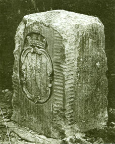
A “crownstone” boundary monument on the Mason-Dixon Line. These markers were originally placed at every 5th mile along the line, oriented with family coats of arms facing the state that they represented. The coat of arms of Maryland’s founding Calvert family is shown. On the other side are the arms of William Penn.(Wikipedia photo and detail)
Initially destined to settle a local dispute, the line grew into a more ominous demarcation between the pro-slavery and the ‘free’ states. The line follows the northern latitude of 39 degrees and 43 minutes and today separates four U.S. states: Pennsylvania, Maryland, West Virginia and Delaware.
Mason and Dixon marked every mile of the chart with stones shipped from England. Every five miles the line was marked with a ‘Crown-stone.’ It consisted of the two coats of arms belonging to the adjacent colonies. Many markers survived and they can still be admired. [Read more…]